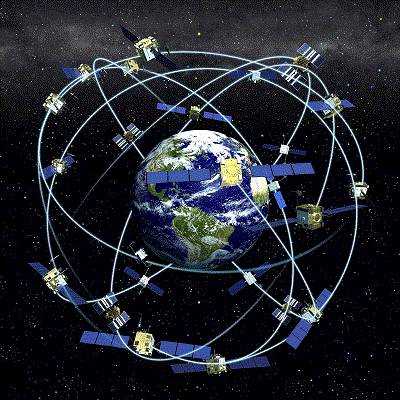
GPS Technologyis a global positioning system, it is basically a space-based satellite navigation system which can provide with the accurate location, time and speed information in all-weather condition and independent of the day or night. GPS Technology works approximately anywhere on or nearby the Earth where there is clear and unobstructed line of sight to four or more special satellites, called GPS satellites. GPS Technology provides some critical capabilities to military, civil and commercial users present all over the world.
It can be freely accessed by anyone with the GPS receiver. This project first started in United States, their aim was to build a navigation system which can located anyone or anything precisely with the location and time, in the year 1973 there struggle meet with fate and GPS Technology was made to overcome the limitation of previous navigation systems.
Generally, GPS receiver are accurate within 15 meter range but newer versions which are in progress, have range less than 15 meters.
Basics of GPS technology
A GPS receiver’s work is to calculate its position by precisely timing the signal sent by GPS satellite present in space. Each of these satellites continually transmits the messages that include:
- The time when the message was transmitted.
- Satellite position at the time of message transmission
The received signal is used to find out the transmit time of each message and also the computation of distance of each satellite is done by the receiver using the speed of light. Now to find the location, speed, time and elevation receiver use the mathematical concept called trilateration i.e. each of the calculated distance & satellites’ location define a sphere. Now, the receiver is supposed to be on the surface of each of these virtual spheres when the satellites’ location and calculated distances are correct. These satellites’ location is used to calculate the location of the receiver using the navigation equation. Speed can be precisely computed using the position change. Now we have the location and speed which is displayed over screen.
Typically this whole GPS operation requires four or more satellite to compute the results because the fact that four or more than four spheres cannot intersect at the same, thus by solving the navigation equation to solve find the intersection, this computed solution will the give the quite accurate location with precise timings. Nowadays, this accuracy and precision is utilized by many GPS application to perform operations like traffic signal timing, time transfer, etc.
Few Limitations of GPS Technology
Cost
GPS Technology system will definitely have price which is possible disadvantage of using GPS Technology
Reception
Working of GPS Technology for tracking purely depends on the reception of signals from the satellites. Hence places having tall buildings, dense forest, skyscrapers or canyon walls can block the GPS signal. GPS signal are not always good for penetrating the indoor spaces well, so there can be some spaces which will not allow accurate GPS navigation.
Accuracy
To work precisely the GPS Technologyneed proper update of Maps this is not possible in real time. So there is possibility that your GPS device may lead you to some close road or may ignore the newly constructed path.
Battery
Most of the GPS device are operated on batteries, there is always a possibility of battery failure in that case external power is required which is not always possible.
List of Top GPS devices
Garmin nüvi 2350LMT
Garmin nüvi 3590LMT
Garmin nüvi 3790T
Magellan RoadMate 5045-LM
TomTom GO 2405 TM
TomTom GO 2535 M LIVE
Magellan RoadMate 1700
Magellan RoadMate 9055
TomTom GO LIVE 1535M
TomTom VIA 1535TM
Best GPS apps for Android
Maps
In world of GPS Technology Google Maps is the first choice of user. It provide best user experience through its lovely features including the indoor maps, voice search, information about public transportation, and other interesting features.
Google Maps is whole new World of services which include Indoor Maps, Google Now, My Places, Google Places, Street View, etc.
Sygic GPS Navigation
Sygic GPS Navigator for Android is most suitable of automobiles. It provide with the voice navigation system which can be configured in several different languages. It provides with significant amount of function highlighting the landscape, 3D view and interactive maps. It also allows you to store map on your device which can be used in offline mode.
TomTom
TomTom is one of the most famous offline navigator and available for Android. Its main features include step by step instruction which can be changed in different languages, alternative routes to avoid traffic, provide fast & reliable maps that require no data connection.
With so many facilities this app comes in a price, and require large amount of space, around 2.3 GB, to install.
Waze GPS
Waze is a GPS application which provides the navigation and traffic information in real time. That’s not all it consists of a special social ingredient which is based on the users. Wazers are able to inform other the current state of traffic, street, or other incidents. This app has a good user friendly interface and is very simple to use.
Navitel Navigator
Navitel is best navigators that provide detailed maps of Finland, Russia, Ukraine, Belarus, Kazakhstan. This navigator is vastly known for its vast range of configuration option, among which include zoom, notices, routes, information and also the possibility to delete the interface data that you do not use.
If you have any queries related to the applications of GPS technology, you can ask it by commenting below..
Back to: TechieOasis- a Geeks Fusion


0 comments: